BERFENDAIR Helicopter Charters provides aerial surveys and photogrammetric mapping services to engineering companies, mining industry, municipalities, state and scientist and many other businesses who need to survey or map land from the skies of BERFENDAIR. We provide our clients with accurate mapping and survey products, at a fair price and on a schedule that will meet your production needs.

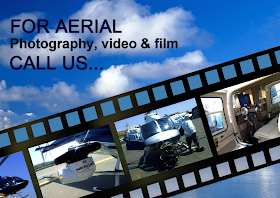
- Aerial filming, photo taking and film shooting by the helicopter,- Aerial Survey, Electric, Petrol and Gas Pipe Lines Control flights,- Heavy lifting, Slung Cargo transportation, Aerial works and flights,- Forest fire-fighting operations by the helicopters,